
By Carlos Alberto Morales Ramírez
Vexilloid Tabloid #63
Potamology—a branch of physical geography—is the study of rivers (think hippo-potamus, “horse of the river” in Greek).
Within physical geography (the subfield of geography that studies natural phenomena in Earth’s hydrosphere, biosphere, atmosphere, and lithosphere through space and time), the study of rivers is found under hydrology (the study of water in all its forms) or under geomorphology (specifically fluvial geomorphology, which deals with the formation and functions of streams).
Continuing my interdisciplinary approach in vexillology, I’ve explored the representation of rivers in flags through wavy bands. For this inquiry I looked at the flags from Puerto Rico’s municipalities as a case study.


Wavy bands in flags can be seen at the national level—Kiribati and British Indian Ocean Territories—and at the municipal level—St. Louis (Missouri, U.S.A). The symbolism of these wavy bands is typically associated with a body of water—ocean, sea, or river.
This is not the only way that a body of water can be symbolized on flags; however it is the most frequently used. Of the 78 municipalities in Puerto Rico, six have wavy bands alluding to a river in the area. In addition, Río Piedras, a former municipality now part of the capital municipality of San Juan, also has a flag with a wavy band.
 Camuy’s flag has a white wavy band interrupted by the Taíno sun. This band represents the Camuy River, which runs east of the municipality and serves as a boundary between Camuy and Hatillo (the municipality directly to the east). This river submerges for a stretch and then re-emerges to the surface within the municipality.
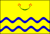
 Quebradillas, the municipality to the west of Camuy, has a flag with two quarters with green and white wavy bands. These represent the small streams, the Guajataca Lake (a manmade lake south of the municipality, shared with San Sebastián and Isabela), and the river of the same name. The river here also serves as a boundary between Quebradillas and the municipality to the west, Isabela.
 The flag of San Sebastián places the wavy band diagonally, dividing the green and red sections of the flag. The band represents the Culebrinas River, which originates in the mountains of the municipality of Lares and runs diagonally through the center of the municipality southeast to the west.
 Similar to San Sebastián, Mayagüez has bands that represent a river that runs through the municipality, the Yagüez River. This river originates in the mountains of the municipalities that border Mayagüez to the east, Maricao and Las Marías. The Yagüez River runs east to west, emptying into Mayagüez Bay.
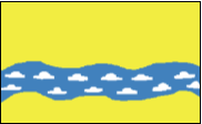
 The Valenciano River is represented by blue wavy bands on the flag of Juncos. This river flows northwest through the municipality until it meets the Gurabo River, a tributary of the Río Grande de Loíza (literally “Big River of Loíza”), the largest river in Puerto Rico.
 Río Piedras also has a wavy blue band representing the river that gives the location its name, Piedras (stones) River. This river marks the boundaries of this area in the municipality of San Juan.


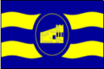
I left the Corozal flag for last because a variant version includes river symbolism. The shield on the flag incorporates wavy bands representing the Corozal River. This river is a tributary of the Cibuco River that empties in the Atlantic Ocean in the municipality of Vega Baja. According to the Flags of the World website, the official flag of the municipality does not have the shield on it, nor does the municipality’s official website mention the shield on the flag. However, images of variants of the flag bearing the shield can be found.

As “honorable mentions” I include the flag of Guánica, where the bands represent the Guánica Bay, and the flag of Loíza, where the wavy bands allude to Loíza as a coastal municipality and having the widest and most abundant river on the island.
Rivers are an important system for humans—as a source of drinking water, food, transportation, ecosystem dynamics—and play an important role in the hydrological cycle. Puerto Rico has 224 named rivers—most of them tributaries of other main rivers—the majority rising in the island’s central mountain range Cordillera Central.
When using flags as instructional tools, it is interesting to explore the ways in which rivers are given importance and symbolism throughout vexillology. Not only do they refer to their local importance or natural phenomena, but they also serve as tool for understanding the concepts of political geography (concerning boundaries and subdivisions) and location.
On each of these flags—literally “a river runs through it”.
Carlos Morales is a PhD student in Geography, currently studying at the National University of Singapore

Hello,I log on to your blogs named “The Wavy Symbolism of Potamological Vexillology—in Puerto Rico – Portland Flag Association” daily.Your humoristic style is awesome, keep up the good work! And you can look our website about daily proxy.